|
|
 |
|
 |
|
|
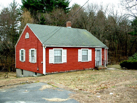
| AT ISSUE... WHAT BUILDING SHOULD REPLACE HOUSE |
|
| Click Image To Enlarge |
Basically, the land appears to be 150' x 150 of which 150
x 100 is currently being viewed as usable.
Because of previous construction of a house to the right
facing and Pine Lake Condos to the left facing, the land is a topographic BOWL on which the above red house is anchored on
the northeast corner. THE DEEPEST PART OF THE BOWL IS THE STREAM OF THE WETLANDS WHICH THEN RISES UP AT THE PROPERTY
LINE.. The house, itself, is already below the grade of Route 135 and Voyagers Lane. As can be seen, the
house foundation is exposed on the sides and back.
Based on an average front door of 6'8", we can guess that
the rooms have a 7 foot height. The roof appears to have a 6/12 pitch, so this modest cape is approximately 13' feet above
grade to the ridge of the roof and 19-20 feet from the ground at the back of the house. The proposed building will be
2.5 TIMES HIGHER.
|
|
|
|
|
|
|
|
|
|
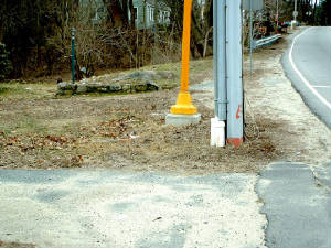
| RT 135 SLOPES DOWN - NO DRAINS |
|
| NOTE: BLUE HOUSE IS A RED LIKE-BUILD. NB LAND FILL EXCEEDS 8' EVEN CLOSE TO HWY |
Facing West on Rte 135: "Every Picture Tells A Story"
and so it is trus of this photo. First, there is the incline of Rte 135... the lack of curbs... the
lack of storm drains... the negative pitch onto the property... the backfill of the neighbor (click to enlarge photo) who
current sits higher and on about equal setback from Rte 135 as the red house. Of course, if current plans hold, the
back of this neighbors home will be facing the front of the build. They should be equally concerned about lighting, plowing, etc.
Oh yes... And one can see the immediate high of a small retaining attempt to level
a portion of the front lawn. In essence, this process is being proposed for the ENTIRE LOT.
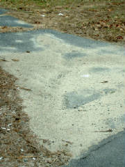
| HOUSE IS BELOW ROAD GRADE - DRIVE FLOODS |
|
| Click Image To Inlarge |
This is he same meager driveway whicdh is at the base the above photo. This photo shows the was that currently
happens onto the driveway because there is a negative slope to the property. It is beging shown for another reason
which follows.
|
|
|
|
There are THREE immutable truths:
1) GRAVTY
is a natural law...
2) WATER follows this law by either
going straight down into the earth or
running down hill if it is thwarted by
oversaturation and there is an incline...
3) So, ALL WATER returns to earth at
the earth's lowest level and through
the path of least resistence
|
|
|
|
|
|
|
|
|
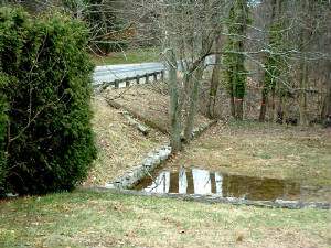
| FIRST SIGNS OF TROUBLE |
|
| POOLING MEANS SATURATION & NEGAIVE SLOPE |
| STORM WATER WRAPS ONTO VOYAGERS |
|
| THEN SOME RUNS ONTO PROPERTY... WHEN ROUTED CORRECTLY IT MUST TRAVEL TO 1st DRAIN AT TREASURE WAY |
| WHY DID PREVIOUS OWNER TOLERATE RUN-OFF |
|
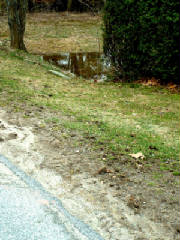
| REFLECTING POOL FROM VOYAGER LANE & RTE 135 RUN-OFF |
Water runing down Rte 135 naturally runs-off onto
the currently unpaved land to the right and infront of the house... OR is WRAPS around onto Voyagers WHERE IT DISCHARGES ONTO
THE PROPERTY... OR continues downward on Rte 135.
CURRENTLY, THERE ARE NO CURBS SURROUNDING THIS PROPERTY.
WHY THE PREVIOUS OWNER TOLERATED THE RUN-OFF FROM VOYEAGER IS A MYSTERY... NEVERTHELESS, THE CURRENT PLANS CALL FOR
A CURB AROUND THE PROPERTY, EXCEPTING THE DRIVEWAY OPENING WHICH COULD BE HUMPED SLIGHTLY TO PREVENT WATER FROM ENTERING THE PARKING AREA.
THIS MEANS, THAT WATER WHICH IS BEING NATURALLY ABSORBED
ALONG THE SHOULDERS WILL NOW WRAP ONTO VOYAGERS AND/OR CONTINUE DOWN HELL.
|
|
|
|
|
|
|
|
|
|
|
This Site Is Developed By
World Wide Web IDentity
|
|
|
|


